« Biofutures: Owning Body Parts and Information | Main | "Binding Memories" on Gutenberg-E »
November 20, 2005
The Book as Landscape: Hypermedia Berlin
"Hypermedia Berlin represents an extraordinary achievement in accessible urban representation. Great cities like Berlin are densely layered and almost inconceivably complex palimpsests. Attempts to represent that historically-layered complexity have, for generations (since the rise of urban research), foundered on the rock of the printed page.
- Peer Response by: Philip Ethington, University of Southern California, 9.14.05
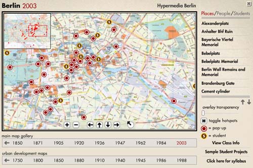
The page itself, one of the most fundamental components of the book, is undergoing a material and conceptual transformation as the static, flat, delimited space of the paper page gives way to the animated, interactive, unlimited, deep space of the digital book. "Hypermedia Berlin" - which grew out of a collaboration between the Stanford Humanities Laboratory (SHL) and UCLA's Center for Digital Humanities (CDH) - represents an excellent example of the formal innovation made possible by digital media. This project crafts an entirely new kind of page out of a gallery of highly detailed, interlinked, illustrated and annotated map interfaces, which can be navigated with an easy-to-use zoom feature. In other words, the page itself has been re-oriented to "landscape." This alternative book form organizes its content topographically and chronologically; encouraging readers to interact with and consider its subject differently. History, the map interface tells us, is tied as strongly to place as it is to time.
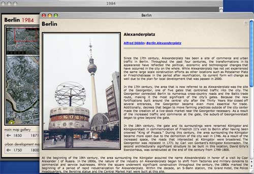
Presently, the site offers 25 navigable maps, "each map, corresponding to a key date in Berlin's nearly 800 hundred year history, consists of an array of virtual reality "hotspots," popup information screens, and critical essays documenting and analyzing significant regions, architectural structures, events, people, and cultural products from that moment in Berlin's history." Using the zoom function, students and scholars can study the maps in detail. The overlay function, which makes maps semi-transparent so that one can be placed on top of the other, allows the reader to analyze changes in Berlin's landscape.
"Hypermedia Berlin" can be used as a multimedia teaching tool as well as a project-based learning environment. For an animated walk-through, visit the "Hypermedia Berlin" project page on the Vectors website.
Over the next two or three years, principle investigators Todd Presner and John Maciuika plan to work with developers to foster new growth for the site. They are connecting the site to a searchable archive of images, hypertext resources and primary sources on Berlin. And they are developing a content management system that will provide a multi-tiered authoring platform. This system will accommodate peer-reviewed contributions and open contributions. The open contribution platform will function like a blog, but posts will be date and location stamped to correspond to a site on the map. For example, a blog post could be connected to a location recently visited, a former residence, or the residence of a relative or ancestor. By providing such a platform, Presner hopes to create a "community memory of place," a memory that will continue accruing over time, as students, scholars and enthusiasts "build" their stories into the landscape.
"Hypermedia Berlin" presents an intriguing possibility. If it is able to harness the power of the network to attract a sufficiently large cache of stories and images and if it can continue receiving an unlimited and ever-growing flow of contributions, then it will succeed in reflecting (in the virtual space) the evolution and complexity of the city itself. An exciting prospect.
Posted by kim white at November 20, 2005 5:02 PM